Tap Into Fun


THE DAN RIVER VALLEY

HAS IT ALL

(APP currently under development)
 
 
The Zone
Northside Drive Entrance

River Park Entrance

(Shiner's Revenge) - Patrick County


Four Paws - Two Feet - Let's Go

 
Reidsville
 
Wentworth
 
Fieldale
 
Patrick Henry Community College
 
(between Madison & Stoneville)
 

Rise to New Levels
North Carolina

 
On The Fly
 
Smith River Access

Philpott Reservoir

Abreu-Grogan Park

Cherio!
Southern Fried Antiques - Madison
Tube rentals (no website) 
call 336-453-4017


Support the Dan River Basin Association


Welcome! The Dan River Basin Association (DRBA) is pleased to provide you with this handy application for finding trails and river accesses in the beautiful Dan River Valley region of North Carolina and Virginia. Support for this app comes from the Reidsville Area Foundation, The Harvest Foundation, and DRBA members.

DRBA works with local governments, community organizations and businesses to help create and maintain: river accesses, hiking and biking trails, river walks and greenways, safe and attractive locations for healthful exercise, and opportunities for children and adults to learn about animals and plants that live and grow here.

For more information on becoming a DRBA member, visit danriver.org, and enjoy the beautiful Dan River Valley!http://www.danriver.org

Virginia Trails

Virginia Trails

in the

Dan River Valley

Regional Map of the Trails (may take a few moments to load) or find each trail below:

Dick and Willie Passage

Richard P. Gravely Nature Trail

Danville River Walk

Anglers Ridge Mountain Bike Trail - Northside Entrance Or Riverside Drive Entrance

Fieldale Walking Trail

Ballou Park Nature Trail

DeHart Mountain Trail - DeHart Botanical Gardens (Rt. 58 between Stuart & Meadows of Dan)

DeHart Park Loop Trail - DeHart Park (Stuart, VA)

IC DeHart Trail System - I.C. DeHart Memorial Park (Woolwine, VA)
 

Laurel Hill - JEB Stuart Birthplace (Ararat, VA)

Mabry Mill Trail (Meadows of Dan, VA)

Mayo River Rail Trail

Pinnacles Trail (Ararat, VA)


Reynolds Homestead LEAF Trail (Critz, VA)


Rock Castle Gorge Trail (Woolwine, VA & Parkway)


Rocky Knob Recreation Area Trails


Blue Ridge Parkway Milepost 169


Round Meadow Creek Loop Trail (Meadows of Dan, VA)


Fairystone State Park Trails (Stuart, VA)


Roanoke Canal Trail

North Carolina Trails


North Carolina Trails

in the

Dan River Valley

(under development - trails not yet listed)


Jobs, Forests & Rivers

Clean rivers are vital to our economy The Dan River Valley is a “water rich” landscape with more than the national average of acres in forest canopy. When DRBA was founded, many of the natural resources in the Dan River Basin were in fairly good shape.

The local rivers were in better condition than they had been when the textile mills pumped dye waste water in them. (Old timers remember the Dan River running in vivid multi-color.)

It would be an overstatement to say there were no environmental problems; however it was lack of jobs in the wake of the textile shut downs and tobacco quota system that most people were concerned about.

Tourism is one area of the Dan River Valley’s economy with consistent growth. While no single industrial category exists to track tourism, there are sectors of the economy that are closely associated, and can be used to indicate long-term patterns of change.

These include components of retail trade; passenger transportation; art, entertainment and recreation; amusement and recreation; museums, parks, and historical sites; and eating and drinking establishments. These can serve as a proxy for tourism-related jobs in order to illustrate long-terms trends and relative size.

Branding our beautiful valley as an outdoor recreational playground offers a range of meaningful opportunities. Small businesses thrive in an outdoor recreation economy: outfitters, guides, production of local, specialty foods, and more.

A recently released report on the economic impact of outdoor recreation finds that 6.1 million American jobs are “directly supported by the outdoor industry,” and “Americans spend $646 billion each year on activities like camping, hunting, and snow sports. This is a bigger economic impact than those of the pharmaceutical and gasoline and fuel industries.” The report points out that America is globally recognized as the leader in outdoor recreation.

Advancements in technical apparel, footwear and equipment for outdoor activities are driving innovation and entrepreneurship, while creating a demand for highly skilled workers in areas like technology, product design, manufacturing, sustainability and global commerce.

A tremendous diversity of career opportunities exists beyond product-related jobs. By building our outdoor recreational venues, we will simultaneously strengthen our position for cultivating higher paying professional and technical jobs in marketing, manufacturing, real estate and other trades.

So join us, the Dan River Basin Association, in our quest to make the Dan River Valley region a great place to live, work and plan.

Adventure Outfitters


Create your own adventure or join in a planned trip with one of our local outfitters, listed below in alphabetical order:

Dan River Adventures
724 Webster Rd, Stoneville
336-427-8530

Find Dan River Adventures

Smith River Outfitters
276-618-1457

Three Rivers Outfitters Website
413 B Church St, Eden
336-627-6215

Find Three Rivers Outfitters

Troublesome Creek Outfitters Website
413-B Church St, Eden
336-627-6215

Find Troublesome Creek Outfitters

River Access

Tap here for a map of access points on the Smith, Mayo, and Dan rivers in Rockingham County as well as local outfitters.

With four rivers providing more than 60 miles of flowing waters, Rockingham County, North Carolina is a haven for water lovers. Our rivers offer an alternative to whitewater with recreational canoeing, kayaking or tubing for all skill levels. Here, you can have a leisurely float on calm water or find thrills across Class II and III rapids.

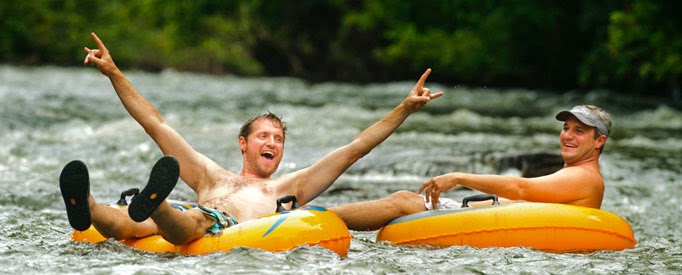
The Dan River: Scenic Family Fun
  • Class I
  • 6 public accesses
  • 1-8+ hour trips
Known by local paddlers as the “lazy river,” the Dan’s calm waters are well-suited for paddlers of all skill levels. It’s also considered one of the best places to learn to paddle in North Carolina. Here, you can have a family tube, canoe or kayak outing, spending the day in nature where almost nothing modern is seen or heard.
The Dan flows 38-miles through Rockingham County along wide floodplains, high banks and tree-covered corridors. It is virtually free flowing with few modern improvements and its waters are plentiful enough that even in times of draught visitors can still canoe or kayak.

During the 19th century the Dan played an integral role in the development of Rockingham County as bateau crews and small steam launches used its waters for commercial river transportation. The Dan's bateau systems are some of the only that remain the country and were the first to be listed on the National Register of Historic Places.


The Mayo River: Rushing Rapids & Smooth Currents
  • Class I, II & III rapids
  • 2 public accesses
  • 1-5 hour trips
The 16-mile portion of the Mayo River in Rockingham County flows through a scenic gorge featuring rock bluffs and two natural waterfalls. The river can be divided into two sections and truly offers something for everyone—from beginners to thrill seekers.

The first portion of the Mayo, the northernmost section, features thrilling Class II and III rapids and is only recommended for very experienced paddlers. Here, the river flows around rock outcroppings, which creates several rapids including the infamous “Boiling Hole” Class III rapid. Avid paddlers say this section offers the best white-water in the Piedmont region of North Carolina.


The lower section features deep, smooth water with a steady current to carry paddlers down river. Beginners and less experienced paddlers will enjoy this section of the Mayo. Paddlers can the use Upper Mayo Beach access to reach both the rapid and smooth sections of the Mayo River.


Mayo River State Park

The Mayo River State Park, located in Mayodan, was the county’s first state park. Established in 2002, it consists of nearly 2,000 acres along the serene Mayo River corridor in Rockingham County and is still in development. The Mayo River State Park's interim facility, "Mayo Mountain Access", features a visitor contact station, picnic shelter, 1.8-mile and .5-mile hiking trails, rest rooms, catch and release fishing pond, and a maintenance facility. One portion of the park contains unique historic structures that were designed by internationally renowned architect Antonin Raymond.

Mayo Mountain Access is located at 500 Old Mayo Park Road, Mayodan, NC 27027.

Contact the park for more information at 336.427.2530 or mayo.river@ncdenr.gov.


The Smith River: For Quick Trips

  • Class I, II & IV
  • 1 public access
  • 1-2 hour trips
The Smith begins in Virginia and runs approximately five miles through Eden until it converges with the Dan. Paddle trips on the Smith River are perfect for those who want to enjoy just an hour or two on the water. The Smith is very scenic with lots of rock outcroppings, foliage and wildlife. Experienced paddlers will even find Class II and Class IV rapids on this river. 

There is one public access point on the Smith at the Smith River Greenway in Eden. This access provides a 2.5 mile float trip to the confluence with the Dan River. 

Three Rivers Outfitters in Eden has private access and offers several trips on the Smith River.


Eden - Smith River Greenway

Tap to find it!
This scenic trail runs along the scenic the Smith River. It is a very popular trail, paved and predominately level and smooth. The trail extends between the Eden Family YMCA on Kennedy Street and Island Ford Landing, walkers will see a variety of interesting plants and wildlife found along the trail.

The Eden greenway along the Smith River was a project of one of DRBA's founders, Mike Covey. The next phase of the planned city-wide system will extend the greenway up river beyond the bridge toward the Spray dam. DRBA thanks City of Eden Mayor John Grogan, members of the Eden City Council, planning director Kelly Stultz, Sam W. Smith, Inc., and the Annie Penn Community Trust (now the Reidsville Area Foundation) for making the greenway a reality.

 Type of trail: Multi-Use Length: 1.5 miles

Mayodan - Mayo River State Park Trails


Tap to find it!
Mayo River State Park - 500 Old Mayo Park Road - Mayodan - Type of Trail: Walking Length of Trail: 1.8 mile loop and ½ mile loop.

Well marked loop trails run along a ridge and feature native plants such as running cedar.

Other park amenities include a park office/visitor contact station, picnic shelter with grills (accommodates up to 100 and may be reserved), three individual picnic pads each with table and grill, and pond fishing (N.C. fishing license required and posted creel limits apply). Total acreage for the entire park is presently 1,967 acres.

The centerpiece is a restored pavilion-style picnic shelter designed by renowned architect Antonin Raymond. A protégé of Frank Lloyd Wright, Raymond introduced a Japanese style of architecture to the U.S., incorporating local materials and creating buildings that are in harmony with the native surroundings.

Weather at Mayo River State Park

Trailhead(s) Directions: Traveling north on NC 220 from Greensboro, take the US 220 Business exit toward Stoneville, keep left at the fork and follow signs for Madison/Mayodan. Turn left on US 220 Business South.

Madison/Mayodan - Idol Park


Tap to find it!

Idol Park - Type of Trail: Walking and Biking - Length of Trail: ½ mile paved trail

This delightful small park features a ½ mile greenway adjacent to a playground and picnic shelters suitable for children on bicycles, walkers of all ages and joggers.
 
Trailhead(s) Directions:
From Greensboro on 220 North, take NC 704 exit toward 220 Business N Madison / Wentworth. Continue on to W. Academy; left onto Westview Drive.


Madison/Mayodan - Farris Memorial Park Trail

Tap to find the park
Farris Memorial Park Trail is a rustic, 1.1 mile wooded walking trail that goes around the lake and crosses the dam. Other park amenities include: 2 fishing piers, one of which is handicap accessible; restrooms, paddleboats, picnic shelters and amphitheater. Events at the park include concerts, miniature golf league, annual fishing derby and the Mayodan Antique Extravaganza.

Park is open April 1 - October 1, but trail can be accessed year-round.
2919 Park Road Mayodan, NC 27021.

Trail Head(s) Directions: From Greensboro on 220 North, take NC 704 exit toward 220 Business N Madison/Wentworth. Follow signs for Madison; turn right on South Market Street; 3rd left onto Decatur Street; left onto Ayersville Road; right onto South Ayersville Road; left onto Park Road. Located 2. 5 miles north of Mayodan.


Reidsville - Lake Reidsville Nature Trails

Tap to find it!
Lake Reidsville Recreational Park
630 Waterworks Road
Reidsville, NC 27320
Type of Trail: Walking
Length of Trail: 3 miles
 
Multiple access points along the lake shore provide glimpses of wintering waterfowl. The park is open daily during daylight hours with $2 entrance fee for non-City of Reidsville residents and $1 for City of Reidsville residents.

Trailhead(s) Directions: from US 29, take Exit 149 (Rockingham Community College Exit). Turn left at the top of the ramp. Go to the first stoplight and turn left, onto US 29 Business/South Scales Street. Go approximately 2 miles and turn right on Waterworks Road. The park entrance is 1 mile on the left. Two nature trails at Lake Reidsville are featured in the NC Birding Guidebook beginning at the southwest corner of the park's soccer field. Walkers can access the trail behind Shelter #1 heading toward the lake. Once at the lake, walk along the shoreline toward the campground, cross a walkway over a small cove, and continue on the trail in the campground area. The second trail head is located south of the Camp Store and weaves in and out of a disc-golf course.

Weather at Lake Reidsville Recreational Park


Reidsville - Jaycee Park

Tap to find it!
Jaycee Park Trail (Reidsville Greenway) 124 Jaycee Park Reidsville, NC 27320 Type of Trail: Walking Length of Trail: 1.44 miles

The first of Reidsville's proposed greenways, the Jaycee Park Trail, is a 1.1-mile path connecting Reidsville Middle School and Reidsville High School on South Park Drive with the Jaycee Park recreation area.

The Jaycee Trail Extension, which was officially opened in May of 2007, connects the Jaycee Ball Park recreation area to the lower Jaycee Park on South Scales Street. The greenway was made possible through a grant from Annie Penn Community Trust (now Reidsville Area Foundation).

Weather at Jaycee Park Trail


SE Rockingham County - Haw River State Park

Tap to find it!
Haw River State Park - 339 Conference Center Drive - Brown Summit, NC 27214
Type of Trail: Walking Length of Trail: 2 miles

Trailhead(s) Directions: At the very headwaters of the Haw River, the 300-acre Haw River State Park features nearly 3 miles of trails through Piedmont forests, fields, and uplands. Trails are accessed behind the Main Lodge.

The park is along the proposed route of the Mountains to Sea Trail, and features The Summit, "a true outdoor environmental learning center, offering optional programming through the Haw River Program (HARP)." Other amenities include: multiple indoor classrooms, two outdoor amphitheaters, a six-acre lake and an expansive boardwalk that meanders through pristine wetlands.

The park is open Monday - Friday 8am to 5pm and closed most state holidays. If the Summit is reserved for a weekend group, it will open during those reservation hours. Visitors are requested to check in at the front desk prior to using trails.
 

Wentworth - Rockingham Community College Nature Trails

Tap to find it!
Rockingham Community College Nature Trails - 215 Wrenn Memorial Drive - Highway 65
Wentworth, NC - Type of Trail: Walking - Length: 5 miles

RCC's nature trails currently comprise the longest trail system in Rockingham County with features including pine and hardwood forests, creeks, waterfalls and a variety of native plant species. There are 3 trail heads: (1) adjacent the parking lot of the Humanities Building, (2) behind the ball field and (3) south of the Historic Village - all on Rockingham Community College Campus. Trail is made possible through support from Rockingham Community College, Reidsville Area Foundation and DRBA members. RCC Nature Trails are open to the public during daylight hours; contact DRBA for a map of the nature trails.